Select Page

In this age of easy to use and highly accurate electronic navigation, conventional paper nautical charts are still regularly used by mariners. Even in cases where electronic charts have replaced them for primary use, paper charts are a reliable backup should the system fail, providing the same navigational essentials at a variety of scales.

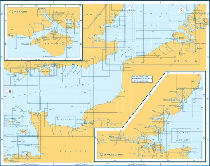
The nautical chart is an indispensable tool for navigation. A chart is a graphic representation of an area of the sea which might also include coastlines, estuaries and islands. All cruising leisure boats should carry up-to-date paper charts. Most also carry electronic charts which are viewed on chart plotters. There are also electronic nautical chart apps which can be downloaded onto tablets and smartphones.

Charts use colours to show land, tidal drying areas, shallow areas and deep water. Actual depths of specific points are shown as numbers. Lines or depth contours join points of equal depth. Charts also show the location of rocks and other hazards, using special symbols which identify the type of hazard.

Tip: Depths of water are normally given in metres, sometimes in feet. The units are clearly shown with the title information of each chart

Latitude and longitude

Horizontal and vertical lines go across a chart at regular intervals, forming a grid. The lines are measured in degrees and are read from scales on the edges of the chart.

  • Lines running across in a horizontal direction are lines of latitude and are known as parallels of latitude. They indicate how far the line is north or south of the Equator, which is at 0º latitude.
  • Lines running in a vertical direction are lines of longitude and are known as meridians of longitude. They indicate how far a line is east or west of the prime meridian (0º), which runs through Greenwich Royal Observatory in the UK.
  • Latitude and longitude are measured in degrees (0º), minutes (‘) and tenths of a minute. There are 60’ in 1º.
  • One minute (1’) of latitude is equal to 1 nautical mile.

Navigator tools

Traditional navigation methods use basic tools including a Breton plotter and single-handed dividers. Navigators use soft pencils to draw position marks and lines on paper charts which can easily be rubbed out after a trip.

To pinpoint a position on a chart, dividers are used to measure the distance to the nearest horizontal and vertical grid lines from the position being measured.

The latitude (distance north or south of the Equator) is found by reading it off the scale on either the right or left edges of the chart. The longitude (distance west or east of the prime meridian) is read off the scale at top or bottom edges of the chart.

To measure the distance from one object or position to another on a chart, the latitude scale at the side of the chart is used. Navigators never use the longitude scale as meridians are not parallel. The distance between them gets less as they converge towards the north and south poles.

Tip: When a position is identified and written down, the latitude is given first, longitude second. For example the latitude and longitude of Port Solent, UK is 50° 50′ 34.7676” N and 1° 6′ 3.6072” W

Scale

Just like land maps, charts vary in scale considerably. They include:

  • Small scale charts (eg 1:350000) which can cover a whole sea, used for planning long voyages.
  • Medium scale charts (eg 1:25000) typically covering a stretch of coastline.
  • Large scale charts (eg 1:6000) possibly a detailed representation of a harbour entrance.
  • Small scale equals large area, large scale equals small area. The actual scale of each chart is shown with the title information.
  • When navigating into harbour, it is best to use the largest scale chart available.

Antifouling for leisure boats – Part 2

To prepare for antifouling, as soon as your boat has been lifted out and pressure washed, you need to check all the surfaces of the hull below the waterline, remove any remaining barnacles and check for blisters.

Light characteristics – how do navigators identify lights at night?

How do navigators identify the different types of light around our coasts at night and what are their characteristics?Navigating at...

Boat engine basics

Boat engines come in all shapes and sizes and include inboards, outboards, petrol, diesel, electric and hybrid systems. Some engines are...

Repairing a leaking hull-to-deck joint

If you suspect a hull-to-deck joint has failed, then being absolutely sure where the actual leak is occurring is of prime...

How diesel engines work

The basic principle of a diesel engine is less complex than that of a petrol engine. No spark plug or ignition system is needed, making the basic diesel engine a comparatively straightforward system that results in fewer faults and has lower maintenance costs than a petrol engine.

How to tackle osmosis

Many owners of old GRP boats live in fear of osmosis, but what exactly is osmosis and what can be done about it? Osmosis comes about...

Navigating the Unknown: Boating in Limited Visibility

Sailing or Motor Boating in limited visibility, whether due to darkness, fog, or other adverse weather conditions, presents unique challenges for mariners. It requires a combination of skill, experience, and adherence to safety protocols to ensure a safe and enjoyable journey. In this article we will delve into the intricacies of sailing in such conditions, providing insights into preparation, navigation, and collision avoidance.

Essential Yachting + Power Boat Safety Briefing

Yachting Safety Briefing   Down below Lifejackets and harnesses - fitting, when to wear, clipping on Gas - risks, precautions, gas bottles and...

Boat Security: Protecting your vessel from theft & vandalism

Boats are susceptible to theft and vandalism. Protecting your vessel from these risks requires a proactive approach to boat security. In this comprehensive guide, we’ll explore the various threats to boat security and provide practical strategies and technologies to safeguard your investment and enjoy peace of mind on the water.

Estimating and plotting your position at sea

This post covers how we go about estimating and plotting our position using traditional methods, when out of sight of land – covering Dead Reckoning, Estimated Position, Tidal Streams, Leeway and more…

Essential Boat Safety Briefing

Skippers Responsibilities Skippers are obliged to give a safety briefing to the crew even if they are a regular crew. At...

Points of Sailing

The course on which a boat is sailing can be described by its angle to the wind, not to be confused with its compass...

ColRegs Nav Lights & Shapes, Rules Of The Road and IALA Buoys Apps

ColRegs Nav Lights & Shapes, Rules Of The Road and IALA Buoys Apps Make Learning Rules on iPhone, iPad, iPod and Android...

Keel design – options to consider when choosing a yacht

Keel design is constantly evolving and nowhere is this more apparent than in modern racing yachts such as the Imoca Open 60...

Sailing at the touch of a button

Easier and more controlled sail handling can also be achieved by powering up a furling mast. I came across some interesting solutions at the Southampton Boat Show this week on the Selden Mast stand, where they were running demos of their E40i electric winch and SMF furling system.

Boating Rules of the Road – International ColRegs

    International ColRegs Rule 7: Risk of Collision Anyone who is responsible for a vessel at sea, from the...

How to Avoid Collisions At Sea With The ColRegs

      Every Skipper Needs Accurate Knowledge of the IRPCS ColRegs As a responsible skipper it is every skipper’s duty to learn and apply the IRPCS...

Keel maintenance and Repair – Part 2

If you have ever witnessed a boat colliding with a rock or other submerged obstacle you will know that there is an almighty thump and the whole boat shakes and judders. While such hard groundings seldom result in catastrophic keel failure, something has to give and even the sturdiest keels can easily be damaged by such an impact.

2023 Rolex Fastnet Race – Part 2

Simon Jollands took part in the 2023 Rolex Fastnet Race. This is the second of his articles on the race aboard Lancelot II, a Beneteau First 40.

Sector lights, directional lights, leading lights – how do they differ?

Sector lights, directional lights and leading lights guide vessels safely through hazardous waters or narrow channels at...

Antifouling for leisure boats – Part 4

Applying antifouling. Antifouling is best applied on a dry, calm day. It is best to apply the antifouling in the middle of the day to ensure the hull is dry and as warm as possible.

Man Overboard Drill

How to respond to crew overboard under sail • Keep the MOB in sight • Tack into the heave-to position, do not adjust the...

Navigating narrow channels

Navigating narrow channels can present challenges for boat operators due to limited space, restricted manoeuvrability, and potential hazards such as shallows, rocks, or other vessels. To ensure safe passage through narrow channels, it’s essential to follow specific strategies and techniques.

Navigation safety: a quick-reference mobile app to learn the ColRegs NavLights and Shapes

 Safety at SeaSafety at sea will always remains a topical and important subject that will no doubt dominate the syllabuses of nautical...

Docking a Motorboat

Docking a motorboat can be a challenging task, especially for beginners, but with practice and attention to detail, it becomes much easier. Here’s a step-by-step guide to help you dock your motorboat safely and efficiently.