Select Page

In this age of easy to use and highly accurate electronic navigation, conventional paper nautical charts are still regularly used by mariners. Even in cases where electronic charts have replaced them for primary use, paper charts are a reliable backup should the system fail, providing the same navigational essentials at a variety of scales.
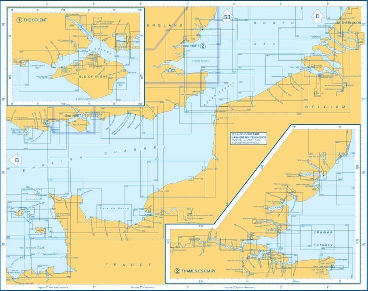
The nautical chart is an indispensable tool for navigation. A chart is a graphic representation of an area of the sea which might also include coastlines, estuaries and islands. All cruising leisure boats should carry up-to-date paper charts. Most also carry electronic charts which are viewed on chart plotters. There are also electronic nautical chart apps which can be downloaded onto tablets and smartphones.

Charts use colours to show land, tidal drying areas, shallow areas and deep water. Actual depths of specific points are shown as numbers. Lines or depth contours join points of equal depth. Charts also show the location of rocks and other hazards, using special symbols which identify the type of hazard.

Tip: Depths of water are normally given in metres, sometimes in feet. The units are clearly shown with the title information of each chart

Latitude and longitude

Horizontal and vertical lines go across a chart at regular intervals, forming a grid. The lines are measured in degrees and are read from scales on the edges of the chart.

  • Lines running across in a horizontal direction are lines of latitude and are known as parallels of latitude. They indicate how far the line is north or south of the Equator, which is at 0º latitude.
  • Lines running in a vertical direction are lines of longitude and are known as meridians of longitude. They indicate how far a line is east or west of the prime meridian (0º), which runs through Greenwich Royal Observatory in the UK.
  • Latitude and longitude are measured in degrees (0º), minutes (‘) and tenths of a minute. There are 60’ in 1º.
  • One minute (1’) of latitude is equal to 1 nautical mile.

Navigator tools

Traditional navigation methods use basic tools including a Breton plotter and single-handed dividers. Navigators use soft pencils to draw position marks and lines on paper charts which can easily be rubbed out after a trip.

To pinpoint a position on a chart, dividers are used to measure the distance to the nearest horizontal and vertical grid lines from the position being measured.

The latitude (distance north or south of the Equator) is found by reading it off the scale on either the right or left edges of the chart. The longitude (distance west or east of the prime meridian) is read off the scale at top or bottom edges of the chart.

To measure the distance from one object or position to another on a chart, the latitude scale at the side of the chart is used. Navigators never use the longitude scale as meridians are not parallel. The distance between them gets less as they converge towards the north and south poles.

Tip: When a position is identified and written down, the latitude is given first, longitude second. For example the latitude and longitude of Port Solent, UK is 50° 50′ 34.7676” N and 1° 6′ 3.6072” W

Scale

Just like land maps, charts vary in scale considerably. They include:

  • Small scale charts (eg 1:350000) which can cover a whole sea, used for planning long voyages.
  • Medium scale charts (eg 1:25000) typically covering a stretch of coastline.
  • Large scale charts (eg 1:6000) possibly a detailed representation of a harbour entrance.
  • Small scale equals large area, large scale equals small area. The actual scale of each chart is shown with the title information.
  • When navigating into harbour, it is best to use the largest scale chart available.

Sailboat rig checks – Part 2

In part two of Sail boat rig checks we run through some useful rig maintenance tips and then finish with a brief look at what a professional rig check involves.

Sailboat rig checks – Part 1

Sailing boat rigs need to be checked regularly to reduce the risk of rig failure at sea. In part one of Sail boat rig checks we run through a series of useful checks that owners and skippers can carry out.

Tidal heights and the rule of twelfths

For those skippers who need to make a quick calculation or don’t have access to specific tidal curves for their location, it is possible to make an approximation using a system called the Rule of Twelfths. This is a simple method used to estimate the height of tide at any given time during the tidal cycle. It is based on the idea that the rise and fall of the tide is not constant, but follows a predictable pattern than can be divided into twelve parts.

Boat Engine Failure – what to check

Engine failure If your engine fails or is overheating there are a number of things to check immediately: • Air filter...

Understanding boat engines

Irrespective of what kind of engine a boat is equipped with and who does the work, the regular care and maintenance of a marine engine is essential. The most common cause of marine engine failure is widely known to be lack of maintenance.

Sterndrive maintenance

Sterndrives are a popular form of propulsion in the powerboat market, but require a fair amount of care and maintenance. The main factors to be aware of are salt water corrosion, lubrication and regular inspection of the bellows, the condition of which is vital to prevent water from entering into the hull.

The give-way hierarchy at sea – who gives way to whom?

Whatever their size or type, all skippers have a responsibility to avoid collisions with other boats at sea.  It is...

Essential Boat Spares for Safety

  Boats Spares Tool kit What you carry in the boats tool kit will be useful for many boat repairs, but you might want...

Jester Challenge 2022 – Sailing single handed from Plymouth UK to the Azores: Part 2 – Weather

Jester Challenge – A modern experiment in old-fashioned self-reliance, self sufficiency, and personal responsibility. This is the second of a 10-part post where solo sailor, Bernie Branfield, shares his first hand account of his single-handed, 2022 Jester Challenge, from Plymouth, UK to the Azores, in his 26′ Invicta Mk2, Louisa.

Essential Boat Safety Briefing

Skippers Responsibilities Skippers are obliged to give a safety briefing to the crew even if they are a regular crew. At...

Antifouling for leisure boats – Part 1

Boats that are kept afloat can very quickly become a home for small marine organisms such as barnacles, weed and slime. Applying an antifouling paint to your hull is necessary to protect it from these micro-organisms, as a fouled hull can cause problems and will slow down a boat’s maximum speed considerably if left unchecked.

Sailing into a storm

Weather forecasting has become increasingly accurate, but despite this, I was caught out recently by a forecast that considerably underestimated the wind strengths and consequently was sailing single handed in to a Force 8 gale, which proved to be challenging!

Passage planning and pilotage

Passage planning and pilotage help skippers navigate safely from one port to another. A passage plan takes into account all...

Tacking a sailing boat

Tacking is the sailing manoeuvre used to change a boat's direction through an oncoming wind. Tacking a sailing boat calls for the crew to work as a...

Fractures, sprains and dislocations at sea

Moving about a boat at sea often results in a few knocks and bruises, but if a crew member has a fall or major bump and is in serious pain, they should be examined and treated accordingly.

Fixing position at sea using traditional methods

This post looks at some traditional methods used for fixing a vessel’s position at sea, within sight of land. Electronic fixes using chart plotters are very straightforward to record, but if for some reason a vessel’s electronics are faulty it is essential that a skipper knows how to use traditional methods.

Steel and Aluminium Hulls

The two metals used for hull construction are steel and aluminium. These are both very strong materials and will last a long time as long as they are cared for, which primarily means protecting steel boats from rust and aluminium boats from electrolytic action.

Anchoring – getting it right

If you can set an anchor correctly with confidence and know your boat will be safe in a secure anchorage, then you can rest in comfort and will not...

Pre-start engine checks

According to the Royal National Lifeboat Institution (RNLI) almost one third of emergency call outs at sea are caused by mechanical failure. Many engine breakdowns are avoidable. The best way to avoid a breakdown is to carry out pre-start checks before heading out to sea.

Boat maintenance below decks

While most interior maintenance work can be done when a boat is afloat, some jobs such as servicing the seacocks have to be done ashore. It makes sense to do any major interior repairs and improvements with the boat hauled out in the boatyard.

Right boat vs Wrong boat – Over 30 Ways to Cut the Cost of Your Sailing and Cruising

Sailing and cruising offer unparalleled freedom and adventure, but they can quickly become costly. Fortunately, there are numerous strategies to help you enjoy the open water without breaking the bank. Here are over 30 practical ways to cut your sailing and cruising costs.

Care of boat batteries

Boat batteries need to be kept properly charged, which means never allowing the batteries to discharge below 50 per cent of their total charge. As well as the batteries themselves, keeping a boat’s charging systems in good shape will also help to keep batteries topped up to a higher level of charge.

Marine engine oil system maintenance

The regular maintenance of a marine diesel is key to preventing engine failure at sea. This means doing regular checks of the fuel, cooling, electrical and oil systems.

Medical Emergency at Sea

How to deal with a medical emergency afloat   If you are planning a boating trip, it is important to have at least one...

Preparing for sailboat cruising

Preparing for a sailing trip entails a lot of planning. In this blog, we take a look at some of the many safety aspects that a skipper needs to consider before heading off on a cruise.